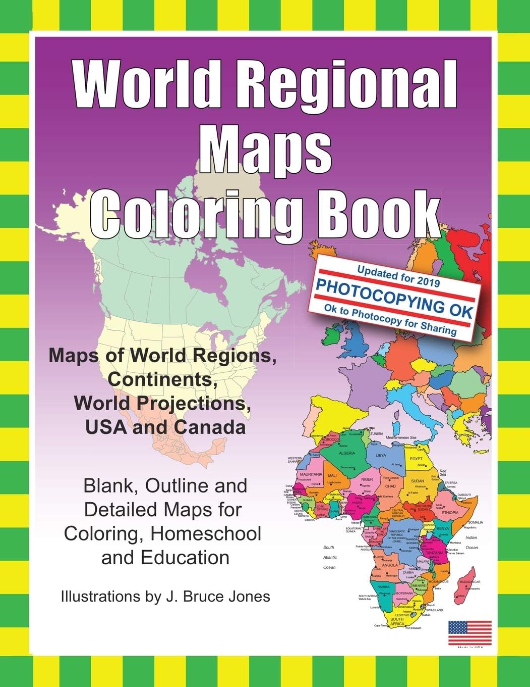
World Regional Maps Coloring Book: Maps of World Regions, Continents, World Projections, USA and Canada
Product ID: 8136624
Buy anything from 5,000+ international stores. One checkout price. No surprise fees. Join 2M+ shoppers on Desertcart.
Desertcart purchases this item on your behalf and handles shipping, customs, and support to Iceland.
World Regions Coloring Book with blank and outline maps is great for learning world regional geography, coloring, homeschool, and education. Learn and color blank and outline maps of the world and its regions. Each blank, outline, printable continent map is presented with a detailed version with political borders, country, capitals, major city names and country name, and then an outline map with just country names and a blank outline map without any of the information, great to color however you want. Students can trace the outlines of the map, study and highlight continents and features on the blank map. A great resource for students and teachers. Black outline blank world maps included in the coloring book are: World Maps – Robinson Projection World Maps – Mercator Projection United States Outline Maps, with and without names Canada Maps, with and without names World Regional and Continent Maps: Africa Map Asia Map Australia, Oceania Map Australia Map Europe Map Maps of North America including Canada, USA and Mexico South America Antarctica Map Additional world regions maps included are: Russia Map Central America and the Caribbean Map Central America Map Europe to the Ural Mountains Map Eastern Europe Map Eastern Europe – Balken Regional Map Middle East Map Mediterranean Regional Map Latin America Map Scandinavia Map Southeast Asia Map Maps come with and in a blank version without names. The printable, blank, outline regional maps in this coloring book can be freely photocopied by a teacher or parent for use in a classroom or for homeschool lessons. World Regional Maps Coloring Book, updated for 2019. Review: Nice resource for geography. - Great educator resource. Review: Adult Brain Puzzles. Good design makes it easy to quiz yourself. - I bought this for myself, to keep my brain "sharp". So far, I haven't done as much with it as I planned, as I wanted to study every continent--but, I now know all the countries in Africa and can find/label them on a map. And I'm working on learning their capitals, too. I think it's important to know enough World Geography to be able to follow the news, and so many people I know don't have that basic knowledge. This makes it fun to learn and easy to quiz myself, as I can make as many photocopies as I need, and compare my answers to the labeled maps included in the book. Eventually, I'll tackle other continents, but Africa was it's own accomplishment. Do you know how many countries there are in Africa? Take a wild guess. ;)


| Best Sellers Rank | #102,692 in Books ( See Top 100 in Books ) #31 in World Atlases & Maps (Books) #44 in Social Studies Teaching Materials #1,257 in Children's Coloring Books |
| Customer Reviews | 4.6 out of 5 stars 487 Reviews |
A**A
Nice resource for geography.
Great educator resource.
J**E
Adult Brain Puzzles. Good design makes it easy to quiz yourself.
I bought this for myself, to keep my brain "sharp". So far, I haven't done as much with it as I planned, as I wanted to study every continent--but, I now know all the countries in Africa and can find/label them on a map. And I'm working on learning their capitals, too. I think it's important to know enough World Geography to be able to follow the news, and so many people I know don't have that basic knowledge. This makes it fun to learn and easy to quiz myself, as I can make as many photocopies as I need, and compare my answers to the labeled maps included in the book. Eventually, I'll tackle other continents, but Africa was it's own accomplishment. Do you know how many countries there are in Africa? Take a wild guess. ;)
C**C
Fabulous maps and ok to copy
These are super. For my project it would be nice if they were all the same scale size and could be used to fit together but they offer outline, very detailed and basic detailed ones of each map. I do question why in Oceania view Australia did not show the territory lines as it shows states and Canadian territories on North America. But these are fantastic maps and freely reproducible. I used then to color in where I've traveled (thus the scale comment) and I like the ones with the country name and Capitol over the very detailed ones. THESE WOULD BE GREAT FOR TEACHING, says the former teacher.
T**M
Great resource
The maps were great for geography class I am teaching. Ages 9-11 is very appropriate. Some colored maps would have been a bonus, but the maps being printable and very clear makes this booklet absolutely worth every penny.
G**S
Coloring book and geo-political map resource
I use this book partly as a general atlas and partly to learn the political geography of a specific country in relation to others. There are pages with state/country borders and names, others without names, and others with just outlines of the same land mass--great learning tool! Gel pens work to color these pages--bright colors and no bleeding.
C**L
Simple is better
My four year old loves maps and he has spent hours coloring and cutting out all the countries in this book. It’s perfect!
R**N
Everyone needs this book
It is the best teaching tool for anyone who wants to learn world geography. I loved coloring all the maps. The fact is you can even photocopy the pages. I think this book belongs in every school. We live in a connected world. While I love home in the USA having traveled I know it is not the only place with culture and customs worthy of study. If everyone put some effort into learning about the world we world all be better off. I happen to be 71 and I bought it for other friends in their 60's and 70's.
A**R
a delightful little coloring book
a great way to learn the countries of the world. it takes each continent and you fill in the countries, a lot of fun.
.**R
Nice world colouring book
Perfect condition. Lightweight, not bulky. Nice variety of maps. Some labeled, some left blank to help with different learning techniques. I also bought an atlas to go along with this book for reference and labeling.
M**J
Great colouring book
bought this colouring book for my son’s 8th birthday is completely obsessed with it always takes it out whenever we need to take learning materials out with us
S**E
Fantastic!
Absolutely brilliant world maps for colouring and teaching kids about geography.
S**C
Awesome educational tool for kids
Awesome educational tool.
L**L
Mappa Mundi, in different ways
This is a useful book as a learning tool. Double copies of most outline maps are produced, and can easily be scanned or copied The versions offered are continent focused maps which are named and with boundaries drawn in; continent focused maps with boundaries, but the countries/regions are un-named, and continent outlines only so the student will need to draw in all countries themselves. World maps in both Mercator and Robinson Projections; Europe Global Projection; North America Global Projection The Continent and Regional Maps. each with 2 copies each of the 3 versions detailed in paragraph 2 are : Africa; Antarctic Region; Australia, Oceania; Australia; Southeast Asia; Asia; Russia; Central America and the Caribbean; Central America; Europe; Europe to the Ural Mountains; Middle East; Middle East Close-up; North America; South America; Latin America; Southeast Asia to Australia; Eastern Europe; Eastern Europe - Baltic Region; Scandinavia; Mediterranean Sea Region; United States of America; Canada As can be inferred from the above, there is a Eurocentric bias, which may not suit everyone, but it is exactly what I wanted for a project, which my huge, weighty and expensive glossy world atlas books, one by Phillips ( a historical atlas) and one by Collins don't satisfy. It is the simplicity and very basic outline quality of borders which makes this work
Trustpilot
2 weeks ago
2 months ago