


🧭 Navigate Boldly, Explore Limitlessly
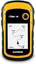
The Garmin eTrex 10 is a compact, rugged handheld GPS navigator featuring a 2.2" monochrome display optimized for battery efficiency and visibility in any light. Waterproof and dust-resistant, it supports paperless geocaching with GPX file compatibility and stores over 1000 waypoints. Equipped with a high-sensitivity GPS/GLONASS receiver and HotFix satellite prediction, it delivers fast, precise location tracking even in challenging environments. Powered by two AA batteries, it offers up to 25 hours of continuous use, making it the ideal companion for outdoor enthusiasts and professional travelers alike.


| ASIN | B00542NV32 |
| Are Batteries Included? | No |
| Audio Output Mode | speaker |
| Battery Average Life | 25 Hours |
| Best Sellers Rank | #194,586 in Electronics ( See Top 100 in Electronics ) #132 in GPS Trackers |
| Box Contents | GPS |
| Brand | Garmin |
| Brand Name | Garmin |
| Compatible Devices | Personal Computer |
| Compatible with Vehicle Type | Car, Truck, Motorcycle, etc. |
| Connectivity Protocol | Bluetooth |
| Connectivity Technology | USB |
| Control Method | Touch |
| Customer Reviews | 4.3 out of 5 stars 6,314 Reviews |
| Display Type | LCD |
| Global Trade Identification Number | 00753759975845 |
| Human Interface Types | Buttons |
| Item Dimensions L x W x H | 5.4L x 3.3W x 10.3H Centimeters |
| Item Type Name | handheld |
| Item Weight Unit of Measure | 141.7 Grams |
| Manufacturer | Garmin, Garmin |
| Manufacturer Contact Information | Garmin |
| Manufacturer Part Number | 0100097000 etrex 10 |
| Map Coverage Type | Satellite, Worldwide |
| Memory Storage Capacity | 6 MB |
| Model Name | Etrex 10x |
| Model Number | 010-00970-00 |
| Model Year | 2011 |
| Mounting Type | Handlebar Mount |
| Network Connectivity Technology | USB |
| Operating Systems | Garmin |
| Packer Contact Information | AMIT GPS & Navigation |
| Product Features | Waterproof |
| Resolution | 128 x 160 |
| Screen Size | 2.2 Inches |
| Screen Size Unit of Measure | 2.2 Inches |
| Special Feature | Waterproof |
| Sport Type | Running |
| Supported Satellite Navigation System | GLONASS, GPS |
| Touch Screen Type | Resistive |
| UPC | 753759975845 |
| Unit Count | 1.0 Count |
| Vehicle Service Type | Car, Truck, Motorcycle, etc. |
| Warranty Description | 1 year |
S**S
Very good product, Value for Money
Nobody can beat this company and the products
R**A
Garmin
Good product
R**E
Chan
खुप छान प्रॉडक्ट आहे
G**A
Good product for GPS beginners.
Good product for GPS beginners. Kindly mention the fact that this product has no memory card support. If you provide some support sites where one can download Garmin compatible Indian maps, then I would have surely given a thought for the higher version with memory card.
M**H
Nice
Good product ,battery attached with product is easy to use....
D**P
Very happy to enjoyment working in our job
Good perfomance and very very useful in my works
C**A
easy to use
very good product
S**E
Software CD missing in package
No software CD was delivered along with the device. Neither the manual states which software to load from website. The experienced persons adviced that a mapsource software CD used to be delivered in the package before. But, what is the software now ?
D**D
Justo lo que necesitaba
No tiene lujos ni aplicaciones extraordinarias, pero es perfecto para hacer rutas senderistas con la seguridad de no perderte. Es ligero , de pequeño tamaño. no pierde la señal del satélite ,. La pantalla se ve perfectamente con sol y sombra y su manejo no es muy complicado. Por ponerle un pero, para mi gusto le falta un bloqueador de pantalla, pero aún así, muy buena adquisición,
S**X
Ottimo ricevitore GPS e GLONASS
Ricevitore GPS molto preciso. Riceve anche i satelliti Glonass russi; registra velocemente la posizione. Appena acceso contiene all'interno una mappa precariata di tutto il mondo, ma per niente dettagliata: sono presenti solo confini di stato e le principali città, ma senza cartografia e altro, solo l'ubicazione. Ufficialmente Etrex 10 non supporta mappe cartografiche. Attraverso un processo appreso online, grazie a Linux Mint e l'applicativo MKGmapgui, sono riuscito ad installare, nei soli 8 Mb del dispositivo, una mappa cartografica quasi completa della mia regione, scaricata dal sito Open Street Map e BBbike.org. Per quello che serve va piu che bene: è solo uno sfizio scaricare la cartografia; per avere uno sfondo un po' dettagliato alle tracce Gpx salvate. La parte davvero fondamentale sono infatti le tracce Gpx dei percorsi (in montagna e non). Sono liberamente scaricabili da vari siti online tra cui cito Wikiloc, e funzionano benissimo guidandovi sul vostro percorso. Se le tracce scaricate sono prive di riferimenti o waypoint, oppure volete semplicemente modificarle nel loro percorso, è possibile utilizzare il software ufficiale Garmin BaseCamp per studiare il percorso e progettarlo come meglio volete. Utilizzo batterie classiche Eneloop ricaricabili Ni-Mh che hanno un'autonomia infinita, oppure le usa e getta al litio della Varta, con le quali si ha una durata davvero notevole, di più giorni. Assieme al Garmin ho preso anche la custodia originale, che comprende la molla per agganciare il ricevitore allo zaino. Ottimo acquisto, anche nel 2020: lo schermo in bianco e nero da un tocco di retrò, ma ha il plus di non scaricare quasi per nulla le batterie.
T**M
ロガー限定として使えば
ロガーとして使えば満足です。 入っている地図は使い物にはなりません。(大阪、名古屋、東京、などの都市と日本の輪郭が入っている程度) 別途地図を入れる方法もありますが、なにぶんメモリが少ないので実用性は低いと思います。 私の場合は単なるGPSロガーとして使用し、結果をPCに取り込んで処理しています。 単なるGPSロガーとしてなら申し分有りません。 固定に関しては、携帯電話についているような、細いヒモを通す穴が開いています。 他に固定する手段が無いのでオプションのパーツの購入をお勧めします。私は純正のカラビナがつくタイプのものを使っています。
M**N
This is my 4th Garmin gps in the last 22 years and the best yet. Very fast to acquire the satellites even ...
Solid little gps, does exactly what it’s suppose to do. This is my 4th Garmin gps in the last 22 years and the best yet. Very fast to acquire the satellites even in the house under a tin roof. My other older gps and my 2 year old car gps won’t acquire the satellites unless I go outside. I did have to go outside the first time I turned it on but worked in the house every time after that. Garmin’s basic functions hasn’t changed much since 1995. There are a lot of switching pages depending on what you want to see but so did all the others I owned. This is a small screen gps and not a big screen tv so it’s impossible to put all the info on one page. The trick is to play with it and learn it’s as much as possible. My only major complaint is the instruction manual, it sucks big time. I give it 1 star for manual. I would say it’s impossible for a first time user to learns anything useful about the gps, Garmin sure has gone downhill when it comes to instruction manuals. Thanks to the Internet, there is a useful solution for this. YouTube contains all kind of useful instruction video for this model, enough to get you going out and use it with confidence. A major complaint I have seen in the reviews is “battery life”, most people find it is too short on two AA batteries. All my older models (3) took 4 AA and the battery life wasn’t that much longer than this unit. The big difference 2 batteries make is the size of the unit. Take my older model Garmin 12XL. Used 4 batteries and the unit was at 30% bigger but the screen is only about 5% bigger. I used to change my batteries every day before heading into the bush. I recommend you also order from Amazon a pack of ENELOOP batteries made by Panasonic. You get 4 rechargeable batteries that contains 2100 mah (stored power). 2 batteries runs the unit for a solid 24 hours,(first thing I tested), you bring the other two for spares. Never leave home without spare batteries regardless the type you use. No downloadable maps is another complaint I read often, if you want topo maps on your gps, do not order this unit, go for the etrex 20. I did see some videos on YouTube that shows how to download some maps on the unit but I found the quality of the maps were not worth it. I always carry a good quality map and a compass with me, gps or not. Much easier to plot a course with a map and compass then load the coordinates on the gps. I used to hunt in deep bush far from civilizations in northern Canada with gps, map and compass and I can say I have never got lost and have always made it out of the bush. Hope the review helps you.
M**I
100%
Muito bom
Trustpilot
3 days ago
5 days ago