
DOWNLOAD THE APP


Customer Services
Copyright © 2025 Desertcart Holdings Limited
DOWNLOAD THE APP

🌍 Survey Smarter, Not Harder — The Ultimate RTK GNSS for Trailblazers
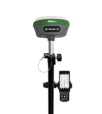
The SMA26 Pro GNSS Receiver is a rugged, professional-grade RTK surveying system featuring full-constellation satellite support, wide protocol compatibility, and advanced tilt compensation for precise measurements in challenging environments. With integrated 4G, Wi-Fi, Bluetooth, and UHF radio, plus a capacitive touchscreen and 32GB storage, it offers versatile connectivity and data handling. Its IP67 waterproof rating, drop resistance, and long-lasting 10,000mAh battery ensure reliable performance across land, construction, and forestry applications.


| ASIN | B0DNLWGPRG |
| Additional Features | NOAA certification, Static surveying, Waterproof |
| Are Batteries Included | Yes |
| Battery Average Life | 2 days |
| Best Sellers Rank | #65,819 in Electronics ( See Top 100 in Electronics ) #65 in Handheld GPS Units |
| Brand | SMAJAYU |
| Built-In Media | 1*GNSS Receiver, 1*extension Rod, 1*power adapter+usb cable,1*user manual, 1*tape measure, 1*terminal antenna |
| Compatible Devices | computer |
| Connectivity Technology | Bluetooth, USB, Wi-Fi |
| Control Method | Touch |
| Customer Reviews | 4.3 out of 5 stars 27 Reviews |
| Human-Interface Input | Touchscreen |
| Item Dimensions L x W x H | 5.51"L x 5.55"W x 3.46"H |
| Item Length | 5.5 Inches |
| Item Weight | 1.03 Kilograms |
| Manufacturer | SMAJAYU |
| Map Type | Worldwide |
| Map Types | Worldwide |
| Memory Storage Capacity | 32 GB |
| Model Name | SMA26 Pro Base |
| Model Year | 2025 |
| Mounting Type | Handheld |
| Operating System | Linux |
| Screen Size | 5.45 Inches |
| Special Feature | NOAA certification, Static surveying, Waterproof |
| Supported Satellite Navigation System | BeiDou, GLONASS, GPS, Galileo |
| Touch Screen Type | Capacitive |
| Warranty Description | 1 year |
K**.
Excellent small GPS GNSS system
Amazing survey grade gps system at an unbelivabe price. Manuals are quite poor and Program not necessarily intuitive... But okay tech support. So plan honor month experimental learning curve. I routinely check into MNDOT published monuments within 0.02 H and 0.04 V ... usimg GS12A-MN.ggf geoid file.. and using MNCORS network using AGRTCM34 mount point and BT tethered to cell phone
P**I
Top notch submeter GPS unit
Top notch GPS unit. No more $5k yellow bricks that conck out and no more subscriptions. The software converts directly to DWG DXF SHP and many other formats and works great with autocad.
J**N
Works well. No RS232 com port
This system works well, but there is no RS232 serial port. Returned it because I was unable to connect it to my data loggers.
P**E
super recomendado
excelente equipo y de alta tecnología me gusta que es rápido.
H**T
The best product i aver use
Really nice and easy to use it
S**O
My first GNSS rover
It was a learning curve as it was my first GNSS instrument but the Support from SMAJAYU was TOP NOTCH. It is a Very solid product and I highly recommend it.
T**Y
Accurate, high quality
High quality and well-thought-out software. Excellent customer service and tech support.
G**A
Buena tienda
Llena la espectativa!!!
Trustpilot
3 weeks ago
2 days ago